A Baby, A Bucket List, and a Birthday - The Slesse Memorial Trail.
 |
| Slesse in Spring |
Question : How long does it take to walk 6 km?
Answer : 6 Years!
Yes, that is how long it took me to finally complete one of the finest hikes in the Chilliwack area of British Columbia, Canada.
Slesse Mountain is an imposing peak of 2439 m at the northern end of the Cascades as the range nudges its way into Canada from the United States.
On the 9th of December 1956 Trans Canada Airline Flight 810 disappeared while on a flight from Vancouver to Calgary. Five months later climbers found the crash site near the third peak of Slesse Mountain. In 1995 a 586 hectare reserve was created around the crash site. Some recovered debris from the crash, including one part of a propeller, are gathered in a heap of stones appropriately named the Propeller Cairn and constitutes the end of the Slesse Memorial Trail.
The trail ascends 940 metres, from 660 metres at the trailhead to 1600 metres at the Propeller Cairn, and traverses a distance of approximately 6.5 km each way.
 |
| Map of area |
The trailhead itself lies about 5.5 km up a logging road (the Nesakwatch Creek Forest Service Road) and this was the stumbling block which prevented me from completing this hike for so many years!
In the autumn of 2009, my dog Baby and I went on an exploratory drive up this dirt road in my low clearance Ford Focus wagon and in about a kilometer into the road I realized that I was going to wreck the car if I was to proceed any further. Worse, this area is out of cellphone coverage and no emergency help is available. I parked the car and hiked up the road to the start of the trail.
 |
| Autumn 2009 |
Exploring a little further, we went down the trail where it crosses the Nesakwatch Creek on a log bridge. It was late in the afternoon and while we relaxed by the water two hikers emerged from the forest on the other side on their way back. I spoke to them and they painted a glowing picture of the rewards that awaited the determined pilgrim at the Propeller Cairn. My appetite was whetted!
It was too late in the evening to start walking and in any case I had not come prepared for a hike, so we returned to the car, I made myself a mug of chai and sipped it contentedly while darkness crept up the valley.
By the spring of 2011 I was driving a 2006 Honda CRV which I nursed up the Forest Service Road and this time it was the white stuff that was the problem - there was no way I could drive it up to the trailhead in the ever deepening snow! Once again Baby and I disembarked, I put on a pair of snowshoes and we spent a pleasant afternoon walking up to the 4 km mark on the road and spending some time on the banks of the creek.
The road continued to draw me like a magnet and we went there again in April 2012, with the same results.
 |
| Spring 2011 |
 |
| April 2012. |
 |
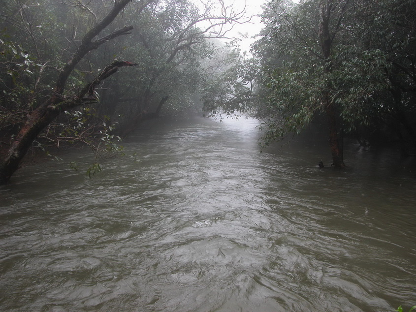
| Spring flow in the Nesakwatch Creek |
Clearly, some drastic action was required - I put the Slesse Memorial Trail on my Bucket List.
This little upgrade had the desired result. 5 July 2015 found Baby and me driving up the logging road in the afternoon with the air conditioner turned full on. Later I was to discover that it was one of the hottest days of the summer in the Chilliwack area, the mercury soaring to a toasty 36 deg Celsius! By the time we reached the Memorial Plaque I was sweating buckets of perspiration even though it was an easy walk. Baby fared no better, her snout had become home to hundreds of pesky bugs and she was panting in the heat and the humidity. I found it hard to believe that I was in the temperate zone of the planet - it felt more like the tropical heat I had experienced while hiking in the Sahyadri range near Mumbai.
 |
| 5 July 2015. |
 |
| The log bridge across the Nesakwatch Creek |
 |
| At the Memorial Plaque. 5 July 2015. |
Poking around in my backpack to locate a utensil to make some chai in, I realized that I had somehow forgotten to pack it in! It was already late in the afternoon and we had a 45 min drive on the logging road before we could reach the Chilliwack Lake Road that would put us within 150 km from home. It would be wise to turn around now instead of tackling the next 2.5 km and 600m elevation gain to the Propeller Cairn.
 |
 |
 |
 |
 |
| ..... and quiet flows the Nesakwatch. |
Three months later, on the evening of 26 September, we arrived at the Riverside Recreation campsite at the junction of the Chilliwack Lake Road and the Nesakwatch Creek Forest Service Road and settled in for the night. It was a cool evening and the near full moon's silvery light filtered through the trees as we went to bed. I programmed the alarm on my smart phone for 5 am - this time I was not going to be beaten back by a lack of time! The forecast was good and the day was expected to be clear and sunny.
 |
| Propane heater (right bottom) ensures Baby gets a good night's sleep before the hike! 26 Sept 2015. |
We left the campsite at 5:40 am and were walking down to the creek from the start of the trailhead an hour later. It was a chilly morning that dictated I walk with my fleece jacket on. Over the next one hour our paths crossed with three groups of Army cadets descending from near the Memorial Plaque where they had camped the previous night.
By the time we arrived at the Memorial, the east face of Slesse Mountain was brilliantly lit and the sun picked out the sharp edge of the imposingly elegant north east buttress in sharp relief. Things were going according to plan and I was thrilled that the light was just right for photography.
 |
| 27 Sept 2015 |
 |
| The East face of Slesse Mountain bathed in glorious autumn sunlight. 27 Sept 2015. |
The last part of the route is where the trail climbs steeply to the Propeller Cairn at 1600 metres. The autumn grass was stiff with frost and ice had formed over the muddy puddles on the path. The leaves of the blueberry bushes were turning red and different shades of yellow were colouring the the forest. The effort was duly rewarded by tantalizing views of Slesse mountain, especially of the soaring ridgeline of the northeast buttress, regarded as one of the classic climbs in North America.
 |
| Slesse from the Propeller Cairn. North East Buttress is the right hand skyline. |
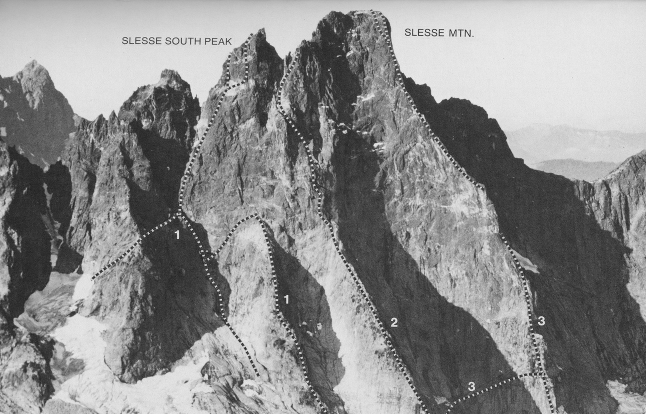 |
| Climbing routes on the east side of Slesse. 1. South East Buttress - South peak (and variations) 2. East Buttress 3. North East Buttress. Photo by Don Serl for A Guide to Climbing and Hiking in Southwestern British Columbia by Bruce Fairley (Gordon Soules Book Publishers Ltd. West Vancouver, Canada in co-operation with the B.C. Mountaineering Club and The Alpine Club of Canada. 1986) |
At the cairn, the propeller juts out of the pile of rocks like a beacon, scratch marks in the metal conveying the frailty of human endeavour. Bits and pieces of wreckage from the crash circle the propeller at the base. The Propeller Cairn is a fair reminder of the unpredictability of our lives, its transience and, when you gaze up at the summits piercing the achingly blue skies, also its intense beauty.
 |
| The Propeller Cairn |
 |
| Baby and Birthday Boy at the cairn |
I brewed myself a cup of chai and ate a sandwich while Baby wisely dozed in the warm sun. It was about 10:15 am and there was plenty of time to scramble up the rocky slope leading to the base of the southern summits below which stray blocks of ice lingered.
 |
| Siesta time |
 |
| View across to the Illusion, Delusion and Rexford group of summits |
 |
I spent a happy three hours in this splendid solitude before six other hikers arrived on the scene, including a couple with a little dog. It was time to go down!
It had been the perfect way to celebrate my birthday.
 |
 |
 |
 |
Link to a brief video I made on the hike :
https://www.youtube.com/watch?v=cVx_q3zEU5I


Comments
Post a Comment